Chapter 11: Future of Transportation Cyber-Physical Systems-Smart Cities/Regions
Objectives
- What is a Smart City?
- Major characteristics of a Smart City
- Smart City as a systems of systems
- Emerging transportation services in the Smart City context
- Smart City developments around the world
- Future research directions
- Conclusions
1. What is a Smart City?
- The ‘Smart City’ paradigm enables integrated operations of digitally connected city infrastructure and service systems (e.g., mobility systems, healthcare, energy infrastructure, public safety) by deploying different communication technologies, real-time data collection infrastructure and data analytics and intelligence platforms to improve the efficiency of city services and to improve quality of life.
- In a Smart City, communication infrastructure, computing resources, sensing infrastructure and data analytics infrastructure (known as the Internet of Things) build the backbone of the cyber-physical system (CPS) and enable synchronised operations of economic, political, social, cultural and urban activities.
- The success of Smart City deployments is largely dependent on an emphasis on adoption of innovative technology based infrastructure and service systems, broader community engagement in the development-deployment-operations of such systems, dynamic leadership and efficient management of resources.
- Depending on the resources available, numerous cities around the world can begin implementing Smart City concepts at different scales.
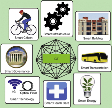
Figure 11.1 Illustration of Smart City components.
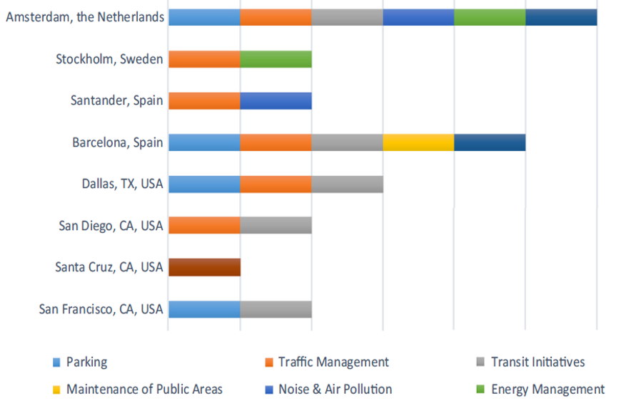
Figure 11.2 Smart City features at selected cities.
2. Major characteristics of a Smart City
2.1 Smart/intelligent infrastructure sensors
- Here we list common sensor technologies in smart transportation systems.
- Loop detectors are used to measure traffic volume, vehicle presence, speed, vehicle classification and detect traffic incidents.
- Microwave radar can be used to detect vehicle flow, speed and presence. Vehicle-mounted radar also supports obstacle detection and automatic cruise control.
- Infrared sensors measure the reflected energy from a vehicle and can identify vehicle type and vehicle characteristics.
- Dedicated short-range communication (DSRC) radio is a two-way vehicle-to-vehicle (V2V) communication technology which can share safety-critical vehicle information to nearby vehicles.
- Cameras are used with traffic signals to monitor traffic (e.g., presence detection and red light compliance). Modern vision technology-supported cameras are used to detect vehicles and are even used in automated vehicles for obstacle detection.
- Light Detection and Ranging (LiDAR) is used in autonomous vehicles to detect obstacles (i.e., other vehicles, pedestrians, roadway-fixed objects) and navigate safely through complex roadway environments.
- Sensors in smart building systems:
- Electrochromic glass which is controlled by electricity to vary the amount of sunlight penetration through windows.
- Lighting control uses automated shading system to sense the available natural light and reduce use of artificial light when it is not needed. There are many lighting control solutions such as Gamma lighting control and automated lighting and a shade control system.
- Sensors in a smart energy grid:
- Automatic smart meters transmit unusual consumption and usage data to the control centre for appropriate response.
- Tollgrade device has been installed on power lines and send a detailed status message in the case of any detected disruptions.
- Weather sensors are used to monitor weather conditions and the temperature of the transmission line.
- Sensors in a smart water distribution system:
- Automatic smart meters are similar to those described for the energy grid. These meters can monitor water consumption and notify control centres of unusual consumption.
- Pressure gauges are used to monitor the condition of a pipeline to identify preventive maintenance and prevent disruptions.
- Temperature sensors have been used to monitor water temperature to detect possible line breaks and notify control centres.
2.2 Big data infrastructure and data analytics capability
- As smart systems are equipped with numerous sensors to monitor the performance of different system components, large amounts of data in different formats (such as text data, video data, structured or unstructured data) will be generated by these sensors.
- The major functions of a big data framework and data analytics system can be divided into three stages:
- (1) data generation and acquisition, which involves collecting heterogeneous data with different spatial and temporal characteristics,
- (2) data management and processing, which involves analysing data and making decisions using data analytics solutions, and
- (3) application, which involves initiating actions based on the knowledge gained. Many cities have been implementing cloud infrastructure to store, process and develop intelligent decisions using a massive amount of data from multiple Smart City infrastructure systems.
- Artificial intelligence (AI)-based data analytics solutions have been used extensively in analysing big data.
- AI methods develop data-driven models and discover significant patterns in the available data. Many companies dealing with big data (e.g., online shopping sites, credit card companies, finance and investment companies) are using AI to analyse big data and develop real-time decisions.
2.3 Communication technologies
- Smart Cities are characterised by numerous and different types of sensors installed in a distributed network to monitor traffic, to collect weather data or to monitor the energy grid.
- Reliable communication and networking infrastructure is critical to connect thousands of sensors to collect infrastructure condition data.
- Depending on the distance, throughput and latency requirements between sensors and key infrastructure components, different communication technologies have been used in Smart City environment.
- These technologies could include combinations of wired and wireless communication options.
2.3.1 Fibre optic networks
- Fibre optic is the most widely used backbone communication infrastructure for any communication network.
- Fibre optic uses light pulses to send information from one place to another.
- The key benefits of using fibre optic networks are high bandwidth, low attenuation, low interference, high security and high reliability over long distances.
2.3.2 Wi-Fi communication
- Smart Cities have been deploying Wi-Fi communication infrastructure to connect their infrastructure.
- For example, New York City’s Linknyc initiative will install 500 gigabyte free Wi-Fi kiosks at old phone booths, which will also serve as charging stations for citizens.
- However, Wi-Fi communication has limited coverage, and the bandwidth widely varies between 25 and 200 Mbps.
- In smart transportation infrastructure systems, Wi-Fi networking has been used to connect vehicles with other vehicles and connect smart infrastructures (e.g., streetlights, traffic signals).
2.3.3 Cellular communication
- Due to the proliferation of smartphone technologies and the evolution of cellular communication technologies (3G->4G->LTE->5G), cellular communication infrastructure plays a critical role in a Smart City environment.
- Because of wide cellular network coverage and large bandwidth, many innovative transportation services such as ride sharing services (e.g., Uber, Lyft), routing support and entertainment services rely on cellular communication and tracking of smart devices.
- As connected and automated vehicles (CAV) will rely on V2V communication for many functions, a fast, reliable, low latent and high-range network system such as 5G could become a key communication platform in future transportation system.
2.3.4 Dedicated short-range communication (DSRC)
- DSRC is a short-to-medium range wireless communication technology exclusively created for intelligent transportation system (ITS) applications.
- It is one of the key communication technologies adopted to enable low latency and high data transmission critical communications for V2V communication-based connected vehicle safety applications.
- Designated licenced bandwidth, fast network acquisition, low latency, high reliability and interoperability are some key features of DSRC communication.
3. Smart City as a systems of systems
- Although the Smart City idea originated with the goal of providing smart transportation services, other city infrastructure and service systems have become an integral part of the broader Smart City platform and formed a true ‘systems of systems (SoS)’ paradigm.
- According to Popper et al., an SoS is ‘a collection of task-oriented or dedicated systems that pool their resources and capabilities together to obtain a new, more complex “metasystem” which offers more functionality and performance than simply the sum of the constituent systems’.
- Because of numerous interactions of different SoS components, a Smart City is explained in this section in the context of an SoS by reviewing major infrastructure and service systems.
3.1 Transportation systems
- Transportation Cyber-Physical System (TCPS) is the most critical and distributed infrastructure in a Smart City’s CPS.
- To provide safe, efficient and reliable mobility services for goods and people, modern transportation systems have been transforming to a smart and intelligent platform supported by V2V, vehicle-to-human (V2H) and V2I communications.
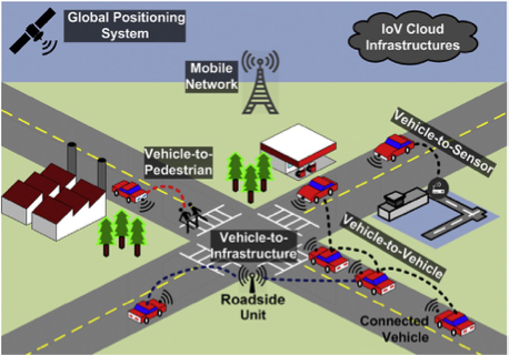
Figure 11.3 A general illustration of smart transportation system.
3.1.1 Smart vehicles
- Although conventional vehicles are equipped with hundreds of electronic devices and form in-vehicle CPS, they do not communicate with other vehicles or transportation infrastructure.
- Advanced vehicle models are equipped with multiple sensors to support safety and mobility features.
- These features include automatic emergency braking system, blind spot warning system, adaptive cruise control system, rear cross-traffic warning system, and lane departure warning system.
- These features provide the vehicle with significant safety and mobility benefits.
- In addition to these features, several high-end vehicle models use cloud services to support advanced drivers’ assistance systems.
- With the rapid progress in research and development, experts predict that automated vehicles will be ready for mass deployment within the next decade.
- Automated vehicles combine multiple sensing technologies (e.g., LiDAR, camera), navigation systems, motion planning algorithms and control systems for driverless transportation of passengers and goods.
- Sensing technologies can identify any obstacles on a vehicle’s path.
- Navigation systems conduct path planning to reach the trip destination from an origin.
- Motion planning systems use sensor outputs and path planning outputs to develop detailed vehicle paths in the next time steps.
3.1.2 Smart transportation infrastructure
- Beyond vehicle-based advanced technologies, transportation infrastructure also has been transforming.
- Agencies operating transportation infrastructure have been deploying technologies to sense, collect and provide transportation system-level condition assessments and predictions to improve safety, mobility and environmental performance.
- Smart transportation infrastructure will accelerate the deployment of automated and connected vehicles.
- Several approaches have been taken by many cities and regions to deploy smart transportation infrastructure such as automated toll collection systems, adaptive signal control, smart streetlights and more.
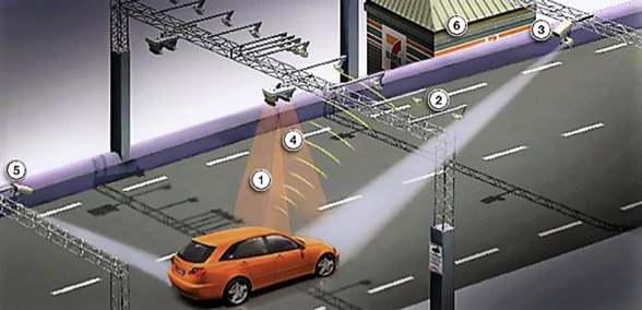
- Electronic toll collection systems have been deployed throughout the world to lessen congestion by allowing vehicles to move fast through toll collection facilities.
- Fig. 11.4 illustrates a typical example of electronic toll collection infrastructure, which includes six major components (numbered 1 to 6).
- When a vehicle breaks the first laser beam (1) entering the toll zone and triggers the transceiver (2), the transceiver communicates with the vehicle’s onboard transponder and captures the date, time and toll charge.
- Simultaneously, a camera (3) takes photos of the vehicle’s front licence plate.
- Next, the vehicle passes through the second laser beam (4), it triggers the second camera (5) and then the second camera takes photos of the vehicle’s rear licence plate.
- The final step is payment deduction from driver’s account or paid via other options such as a website or bank (6).
3.1.3 Smart cloud services
- Cloud-based transportation services have been used in many applications (e.g., Waze, routing planning) and will play a critical role in all Smart City infrastructure and service systems.
- Massive amounts of data collected from sensors in smart vehicles and infrastructure will require huge computing resources and could be supported by cloud services.
- Cloud computing has been used to store, process and analyse diverse traffic data (e.g., vehicle condition data, weather and roadway condition data, real-time traffic signal phasing data, social media data).
- Currently, cloud services have been used for numerous transportation applications, such as adaptive signal operations, real-time traffic condition assessment and prediction applications.
- For example, BMW has launched the smartphone application (app) ‘Enlighten’ to communicate real-time corridor traffic signal information to the drivers of selected vehicle models.
- This app combines data from a city’s traffic management system (i.e., signal data) in a cloud infrastructure and shares route-specific traffic signal data with drivers.
- Using the GPS on a smartphone, this application pinpoints any upcoming signals and analyses the distance between the vehicle and signal.
- With this information, the application notifies the driver whether he/she can maintain the same speed or if they need to slow down.
- ‘Enlighten’ enables stress-free driving by using cloud service-based data collection, processing and analytics tools.
3.1.4 Next generation air transportation system
- Apart from the surface transportation system, air and water transportation systems are two major transportation modes for long-distance passenger and freight movement.
- Because of the high speed, reliability and safety record of air transportation, millions of people use air transportation for long-distance travel.
- Due to an unprecedented increase in air transportation demand, major airports around the world have been experiencing capacity issues.
- In the last century, the modernisation in the air transportation system was not sufficient to serve growing demand.
- To address this issue, the United States has been leading the development and deployment of the Next Generation Air Transportation System (NextGen) and related CPS infrastructure.
- The Joint Planning and Development Office (JPDO) of the USDOT started the initiative to develop the NextGen concept of operations in 2003 to provide the required flexibility in terms of air transportation system capacity including security management and mitigation of the impacts of environment such as air quality and aircraft noise.
- NextGen has set a target to achieve its vision by 2025 and their major objectives are (1) reducing cost, (2) reducing travel time and increasing reliability, (3) fulfilling the future demand and expectation, (4) improving air safety and security of the United States and worldwide air transportation system, (5) mitigating the impacts of weather and other disruptions, (6) reducing noise, fuel consumption and emissions and (7) preventing future threats.
- According to JPDO, the NextGen system will have nine main capabilities: (1) air transportation security, (2) collaborative flow contingency management, (3) efficient trajectory management, (4) collaborative capacity management, (5) flexible separation management, (6) improved environmental performance, (7) improved safety operations, (8) flexible airport facility and ramp operations and (9) integrated NextGen information.
- To achieve these capabilities, NextGen program’s operational CPS has been divided into five subsystems and each subsystem has several functions to support all objectives of the NextGen program.
- The key functions are presented in Fig. 11.5.
- Development and deployment of the NextGen CPS is largely dependent on the coordination and communication between aircraft operations and services, airport services, a safety management centre, an air traffic management control centre and overall security services. Fig. 11.6 shows these different service domains and components of the NextGen system.
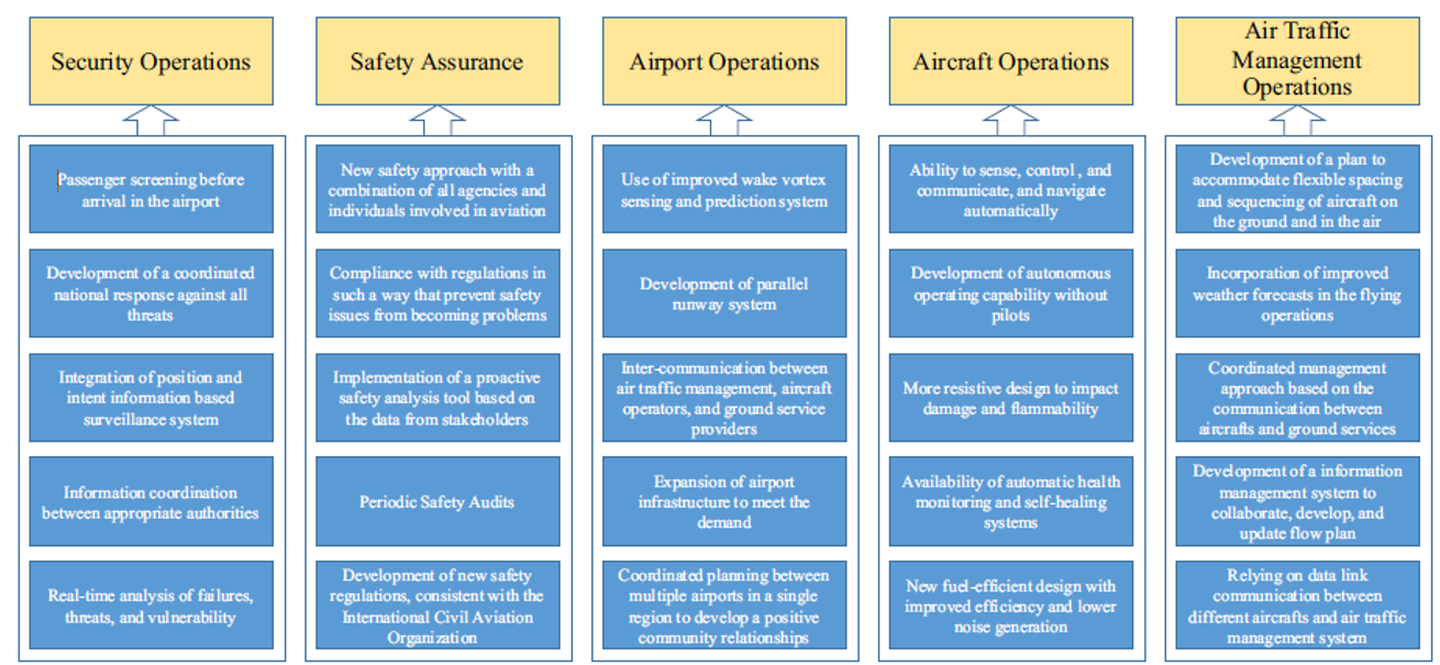
Figure 11.5 Operation of Next Generation Air Transportation System program including the subsections and functions.
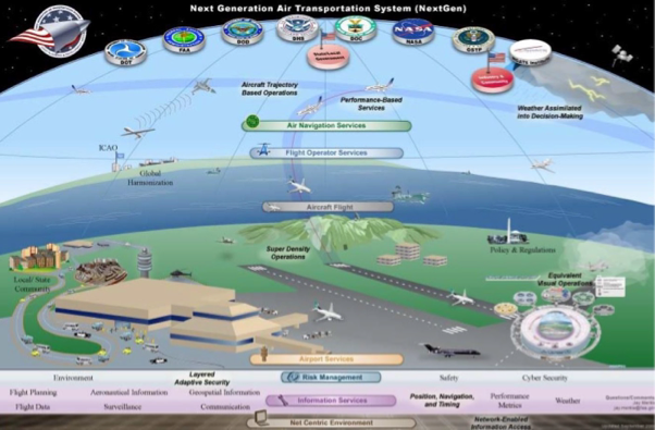
Figure 11.6 Services of Next Generation Air Transportation System model.
3.2 Energy infrastructure
- Energy infrastructure is one of the most critical systems that enables operations of all other Smart City infrastructure. Thus, the importance of transforming energy CPS to be smart, resilient and efficient is vital for prosperity of the Smart City paradigm.
- Emerging smart microgrid technology will help in achieving improved energy efficiency.
- The smart energy microgrid in Wildpoldsried, Germany, is a showcase of such a smart energy system.
- With the collaboration of diverse energy sources (e.g., solar panels, windmills and biogas), this energy system is capable of producing more than five times the energy needs of Wildpoldsried.
- In the United States, Arizona Public Service (APS) has started a pilot project to install two-way microgrid solar panel systems on the roofs of 1600 homes to generate 10 MW of renewable energy.
- This program was a partnership between APS and Siemens where every household will be credited for giving back excess electricity to the utility system.
- Smart energy grid technology will bring new dimensions to Smart City systems through communication with other infrastructure (e.g., wireless charging infrastructure for electric vehicles).
- Some cities and states are even considering to implement the idea of using streetlights as charging stations for electric vehicles.
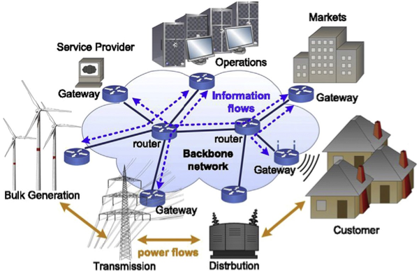
Figure 11.7 The network architecture in the smart grid.
3.3 Public safety
- It is essential that cities can deliver core safety services to the public.
- These services could include safety monitoring and patrols, ticketing, crime investigation and criminal detention, among others.
- Smart Cities should leverage real-time information from multiple sources to enable timely responses to emergencies.
- These information sources could include first responder networks, field personnel reports, video surveillance networks, traffic management centers (TMCs), dispatch centres, public service answering points (PSAPs), Geographic Information System (GIS) databases and other control and command centres.
- Surveillance systems have become quite pervasive in urban areas.
- Transportation agencies monitor roads, intersections and transit stations; law enforcement agencies monitor public locations, police vehicle dashboard cameras and officer body cameras; private sector businesses monitor their stores and other assets and residents use surveillance in their homes and apartments.
- Surveillance continues to be the focus of much investment and combining surveillance with data analytics and network technology hold much promise.
- Disaster management and recovery can be improved through implementation of Smart City concepts, namely by communication and surveillance.
- With respect to communication during disaster response, first responders are of particular importance.
3.4 Healthcare
- Improving quality of healthcare is an important function of Smart City services.
- To cope with limited resources while facing increasing demand, healthcare services must adopt advanced technologies to maximise the efficiency of the healthcare system by integrating traditional healthcare with innovative technologies such as smart biosensors, wearable devices, remote operation and information and communication technology.
- Smart transportation infrastructure could benefit healthcare, enabling many smart healthcare services.
- Smart healthcare has many other benefits as well.
- For instance, using assisted living technology (e.g., smart wearable devices and smart sensors), senior citizens can live independently at their residences without compromising their social activities and healthcare necessity.
- According to Vecchia et al. , RFID and photo sensors can be used to build an intelligent infrastructure for future smart hospitals.
- The prototype of the system will consist of a set of clients, a centralised server and a positioning system which will integrate RFID and photo sensors.
- Through the server, medical staff can check with their patient’s clinical reports, location and movement.
- With RFID and photo sensor technology, hospital authorities can also restrict information access by any unauthorised persons. An overview of this future smart healthcare platform is illustrated in Fig. 11.8.
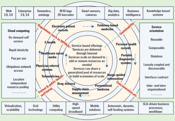
Figure 11.8 Integration of different smart services in a healthcare system.
3.5 Environment
- The environment affected by the transportation system could include the roadside environment, the society it serves and the financial well-being of the region.
- When considering the roadside environmental impact, pollution control, smart energy use, waste generation and resource use are all of concern.
- Pollution control could include reducing emissions, reducing the quantity of runoff while maintaining acceptable runoff water quality and addressing the urban heat island effect.
- When considering emissions, research has shown that efficient operations could have a larger effect than several ‘green’ construction techniques.
- Improving the operation of local city streets by optimising traffic signal timing has the potential to reduce a variety of harmful vehicle emissions.
- It is important to note that these engineering solutions must also be complimented by public policies that help manage demand, ensuring that additional vehicles do not immediately negate the benefits of improved efficiency.
- As scientists continue to observe more unpredictable weather patterns, storm intensity, storm water quantity and quality design assumptions will inevitably change.
- In the meanwhile, cities will need to leverage available data and forecasts.
- Many have engaged citizens to become a part of the improvement in their city’s environmental quality.
- As part of a project from MIT’s Senseable City Lab, citizensin Hong Kong and Shenzhen have agreed to wear sensors to help report the air quality around their cities.
3.6 Other Smart City infrastructure
- Though the transportation system is the largest smart infrastructure system, it does not stand alone as the most important (e.g., water supply system, gas supply system, building system).
- Fig. 11.10 depicts an example overview of different smart infrastructure systems and their interaction through different communication technologies.
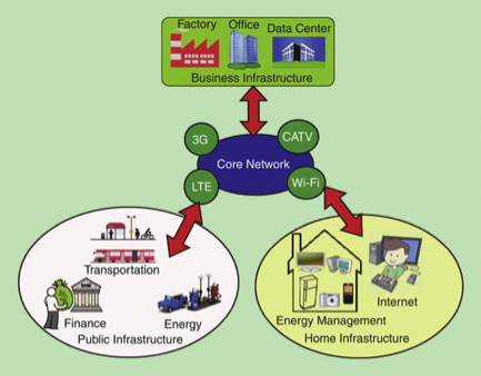
Figure 11.10 Smart infrastructure system.
3.6.1 Smart building system
- Smart buildings maintain communication between different intelligent building components to improve occupants’ comfort and safety and to reduce energy consumption.
- Moreover, smart buildings interact with the external environment and systems (e.g., environmental condition, electrical grids) to provide critical smart building services.
- For example, smart glass windows turn transparent to translucent to block the glass visibility and control light, reducing heat transmission during summer days.
- Siemens’ Desigo Insight, management system for buildings, is one of the most widely used technologies in smart building infrastructure.
- In Tornado Tower, Doha, sensors activate diverse building system components (e.g., heating, ventilation, air conditioning), fire safety, security, video surveillance, control of the smart sensors and control light luminance, all managed by Siemens’ Desigo Insight.
3.6.2 Smart water distribution system
- Smart water grids integrate with Smart City infrastructure through smart sensors, smart meters, digital controllers and analytic tools. Real-time monitoring of asset condition (e.g., pipeline condition), pressure and water quality, water consumption and automated meter readings collection are some key benefits of smart water grid system.
- Many cities have already implemented smart water grid systems to maximise economic and service benefits. For example, Panama City, Florida, has upgraded almost 25,000 existing water meters with smart sensors to address the issue of unaccounted for water usage.
- Implementing these smart sensors has aided the tracking of lost water and identifying system leaks. In addition, this system has improved customer service and efficiency of the system significantly.
3.7 Stakeholders
- Similar to the early days of intelligent transportation systems, there remains a need for strong leadership and champions to motivate the changes for truly improving our cities.
- Some argue that these changes are perhaps part of a larger trend towards reinventing cities and suggest significant potential for change in medium and small cities as well.
- The other part of the challenge in developing Smart Cities is there are so many different stakeholders involved.
- These could include transportation engineers, city administrators, law enforcement, fire and rescue, sanitation services, transit agencies, taxi companies, freight companies and many more.
- Each has different uses for and needs from our transportation system.
- Beyond each stakeholder cluster, it is essential that barriers are removed and the theoretical silos of different agencies and industries are broken down.
- History has shown again and again that information sharing is a challenge, particularly between disparate stakeholders.
- To address these challenges, some suggest that we need new ways of engaging stakeholders if smart cities will help improve stakeholder access and inclusion and/or empower agencies or companies towards being a catalyst in a city’s transformation.
4. Emerging transportation services in the Smart City context
- TCPS has been used as the enabling platform for many emerging transportation services (e.g., smartphone appebased services, smart sensorsebased services) which were not imagined before. In this section, a few major emerging transportation services are discussed.
4.1 Real-time winter road conditions
- In much of the world, winter weather creates maintenance needs to keep transportation facilities in operation.
- Improving assessment of road conditions has long been a topic of interest for transportation agencies.
- To make operational decisions about how to maintain roads during winter weather, transportation agencies and cities can rely on a variety of data sources.
- These sources can be categorised based on the type of information: existing conditions and forecasted conditions.
- Sources of existing conditions could include road weather information systems (RWIS), traffic camera images and reports from maintenance vehicles.
- Traffic cameras along road facilities can also capture key details about winter weather, such as existence of precipitation and coverage/clearance of a road. Unfortunately, reviewing camera images for operational purposes is not efficient when scaled to the number of traffic cameras in larger cities.
- Instrumented winter maintenance vehicles can also provide valuable real-time information about winter road conditions.
- Transportation agencies also purchase weather forecasts from private companies.
- For current practices in winter weather road operations to mesh with the envisioned Smart Cities paradigm, several changes need to take place.
4.2 Smartphones and traveller information
- Personal computing and communication devices are ubiquitous in today’s world and show no signs of fading.
- These devices provide two primary uses for Smart Cities: information dissemination and data collection.
- Applications in these two areas are well developed but the roles of public and private participants are overlapping.
- Recent research has found that smartphones have become so pervasive that they are shifting the needs of public transit riders.
- Many smartphone users can already receive alerts based on their location, their preferences and the applications they install.
- Specific to traveller information, both private and public sector apps are available in many regions.
- Smartphones and other personal computing devices also play a valuable role in data collection.
- The most common application is using mobile phones to identify the travel time along a specific section of roadway.
- On the contrary, some travellers enroll to become participants in such data collection.
- For example, Waze allows users to input and/or confirm information such as roadway debris or stalled vehicles.
4.3 Smart streetlights
- Traditionally, smart streetlights refer to lights, which would make roadway sections or parking lots brighter by detecting a person/vehicle and/or dim after vehicles and people leave.
- The concept of smart streetlights has evolved.
- These systems can be used to disseminate emergency warnings (e.g., news on upcoming hurricane) or display important information (e.g., status of approaching signal through a connected display unit).
- Smart streetlights can reduce energy consumption significantly by demand-based utilisation of energy.
- A networked LED streetlighting system can connect with emergency services such as 911 and could promote safer highways through video surveillance of pedestrian movements.
- Some cities are implementing the concept of smart streetlights with diverse functions.
- For example, Shanghai, China, has installed 15 lamp posts fitted with touch screens and surveillance cameras.
- These streetlights are capable of providing free Wi-Fi, collecting traffic conditions and acting as a charging station for electric vehicles.
- Moreover, every one of those 15 lamp posts is equipped with an emergency button, providing immediate access to the city’s public services, including police and firefighters.
4.4 Smart parking services
- Vehicles looking for a parking spot in a downtown business district account for a significant portion of congestion.
- According to Shoup, the amount of vehicles that are cruising for parking account for almost 40% of total traffic volume.
- This additional traffic causes traffic congestion, wasted time and wasted energy in the form of fuel.
- For example, in Los Angles, California, searching for parking spots creates around 730 tons of CO2, 95,000 lost work hours and wastes 47,000 gallons of gasoline annually.
- Providing motorists timely information about available parking spaces could reduce congestion.
- There are various smart parking concepts that are deployed in many cities around the world.
- An overview of several of the prominent concepts is presented in following subsections.
4.4.1 CoPark approach
- This smart parking system uses V2V and V2I communication to locate any unoccupied parking spaces within the shortest possible travel time.
- This decentralised system uses wireless communication among smart agents (e.g., smart Wi-Fi sensors) installed in a vehicle to inform others about any unoccupied parking space.
- In this system, a roadside unit installed at the parking entrance informs and guides approaching vehicles to the nearest vacant parking spaces.
- Fig. 11.11 illustrates a sensor-based parking system that uses wireless communications to detect the presence of vehicles and send the information to a server.
- Other vehicles can communicate with the server to identify available/empty parking spaces and their locations.
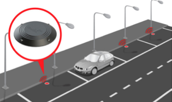 Figure 11.11 Smart parking system using sensors.
4.4.2 Park and ride approach
- In the suburbs of San Francisco, California, Rockridge Bay Area Rapid Transit is the first smart park and ride system in the United States.
- In this smart parking system, anyone can park at strategically placed parking facilities and ride on a fixed route commuter bus or a train to reach their destinations.
- It typically provides real-time traffic information to users through message signs about vacancy of parking spaces in each lot, departure of the next bus or train and downstream traffic condition.
- Based on the real-time parking and traffic congestion information, one can easily decide whether to use park and ride or drive their own vehicle.
4.4.3 Crowdsourcing-based approach
- Crowd Park is a social networking application that allows individual drivers to book a parking space and prepay the parking fee.
- Using the sensors of a smartphone, it is possible to detect a driver’s transportation mode, such as whether they are driving or walking.
- If a transition pattern is identified, such as driving/stopped/walking, the system could conclude that the vehicle is parked.
- The application can also detect whether the traveller is walking towards the parking lot and inform others of a prediction that a parking spot could be available soon.
- Moreover, driverscan upload information at their own will to let other drivers know when their parking spot is going to be available again.
4.5 Smart intersections
- The smart intersection concept is enabled by real-time communication between motor vehicles, public transport, traffic signals, emergency vehicles, cyclists and pedestrians for safe and efficient operation of multimodal conflicts at intersections.
- As future CAV will communicate with each other with V2V and with traffic signal systems through V2I, legacy traffic control systems at intersections need to be modernised.
- Important features of smart intersections include smart optimisation of signal phase and timing (SPaT) applications, information sharing with approaching vehicles about safe speed, eco-friendly signal operations, intersection safety warning and collision avoidance.
- Though CAV technologies are mostly under development, many large cities have been demonstrating the idea of smart intersections to improve mobility performance.
- Pittsburgh, Pennsylvania, US, is one of the first cities implementing this smart intersection idea.
- A pilot project of 18 intersections at East Liberty and Shadyside, the smart traffic control system concept was implemented through the use of a intersection camera and radar detection system.
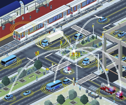
Figure 11.12 Vehicle-to-infrastructure communication in multimodal transportation systems.
5. Smart City developments around the world
5.1 London, England
- London, England, has made noteworthy efforts towards the Smart City concept.
- Strong leadership, combined with public involvement, has been the key to this success.
- Examples of these efforts include the London Dashboard, the London Datastore initiative, the Freight Electric Vehicles in Urban Europe (FREVUE) electric freight demonstrator project and the 2050 Infrastructure Plan.
- The London Dashboard provides a wealth of information about the city, with a notable emphasis on real-time transportation information.
- This includes Tube status, the current and forecasted bike availability, bus service status, open-source street maps and a variety of traffic cameras;see Fig. 11.13.
- Next, the London Datastore provides a data-sharing resource for public officials, citizens and businesses alike. Information includes transport performance data, school placement maps, house pricing information, forecasted growth scenarios, infrastructure mapping and a series of blogs.
- This abundance of available and useable data has led to the development of approximately 400 smartphone apps to further enhance the public’s use of this resource.
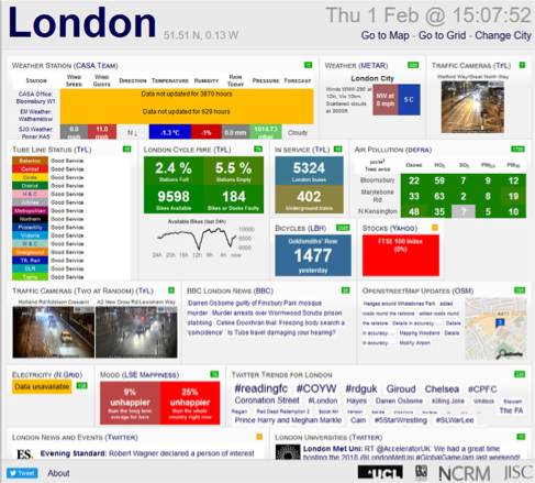
Figure 11.13 Example city dashboard, London, UK.
5.2 Seoul, South Korea
- South Korea has been pursuing Smart City concepts for some time.
- Songdo, South Korea, is considered as the world’s first Smart City, built from the ground up with this concept in mind.
- Although the final results are still unclear, nearby Seoul has also made strides towards the goal of becoming a Smart City.
- They planned to reach their goal in three steps: building the Smart City infrastructure, providing Smart City services to citizens and travellers and continue advancing smart services from 2015 and beyond.
- Services to the public now include free Wi-Fi at many public spaces, including subways trains, parks and government buildings.
- Approximately 10,000 free Wi-Fi locations were initially planned.
- To help low-income and vulnerable populations benefit from these services, plans were developed to distribute used mobile phones to 200,000 citizens per year.
- To improve public safety and security, Seoul officials increased surveillance monitoring and implemented automated monitoring of the videos, which enabled all videos to be reviewed instead of only 30% (when done manually).
- There was also a notable focus on surveillance and monitoring for school safety.
5.3 Singapore, Singapore
- Singapore is a unique case because the government is striving for not just a Smart City but a smart nation.
- In addition, it is unique because of the overwhelming government ownership of housing, nearly 80%.
- These two factors lead to many interesting challenges and opportunities for Smart City projects.
- Singapore was named the smartest city in the world in 2016 by Juniper Research.
- Advanced transportation played a significant role in earning this recognition.
- Best practices learnt from Singapore’s implementations suggest using pilot projects before implementing anything citywide.
- The city has implemented at least a dozen pilot projects.
- To develop and test ideas faster and with less costs than in the real world, Singapore officials are making a digital model of the city called Virtual Singapore.
- This model will include real-time information about the population, the climate and much more.
5.4 Columbus, Ohio, USA
- The city of Columbus, Ohio, is located in the Midwest of the United States.
- This city was included as an example of Smart City development because they were chosen as the winner of the USDOT’s 2016 Smart City Challenge.
- The Challenge attracted applications from 78 cities throughout the United States and helped shape a picture of how Smart City concepts could address the urban mobility needs of midsized US cities.
- Common themes among these applications included the need to provide better first and last mile services for public transit riders; improving the movement of goods into and within cities; coordinating data collection between systems, agencies and market sectors; improving parking efficiency; reducing CO2 emissions and optimizing freeway and arterial traffic.
- The proposed developments that were keys to the Columbus Smart Cities proposal were strong publiceprivate relationships, accessibility and sustainability.
- The city of Columbus worked closely with private companies in their region and was able to transform the USDOT’s $40 million award into a $140 million commitment.
- Another key element to the Columbus Smart Cities proposal was accessibility for all.
- Their plan targeted specific challenges to their region, including high infant mortality, limited access to jobs for the socially and economically disadvantaged and limited travel options for visitors.
6. Future research directions
6.1 Technology
- To realise the anticipated benefits of Smart City, several technologies must come to maturity through continued research and development.
- These include DSRC devices, SPaT transmission systems and automated vehicle sensor processing.
- There are a variety of wireless communication options available for vehicle manufacturers and transportation agencies to consider.
- These include 5.9 GHz DSRC, Wi-Fi, Bluetooth, RFID systems, cellular communication systems and worldwide interoperability for Microwave Access.
- Although many of these are well established and commercially available, they might not have low enough latency to meet the safety needs of automated or connected vehicle applications.
- DSRC appears to meet the latency requirements, but there are limitations requiring availability of clear line of sight.
- Future research should continue identifying best practices for using this communication platform.
- Another key area for future research is the dissemination of traffic SPaT information.
- Traffic signals control an overwhelming proportion of intersections within cities.
- Last, future research should continue investigating ways to make automated vehicles safer for the public.
6.2 Interdependency
- Different systems in a Smart City environment rely on the integration of modern technologies to provide efficient services to enhance the quality of citizens’ lives. Implementation of a Smart City ecosystem consists mainly of changes to the transportation system.
- This system includes CAV, deployment of smart parking systems, execution of smart streetlight systems and other Smart City services. These systems are largely dependent on smooth integration with communication and data analytics infrastructure and developing interdependencies between system components and between systems.
- With the increase in interdependencies, interoperability issues could arise because of the inability of legacy infrastructure to interconnect with modern technologies.
- Smart City design and deployment must address these issues and reduce failure risk due to complex system interdependency.
- Security risks for communication infrastructure, such as phishing, data falsification and spoofing, could compromise the quality of Smart City services and users’ privacy. Such events could even shut down the whole system.
6.3 Resiliency of interconnected systems
- Natural disasters and man-made disasters have been testing resilience characteristics of modern transportation system and other Smart City systems.
- With the deployment of modern technologies and their performance during extreme weather events, modelling and study of smart systems’ resilience characteristics have become more critical.
- According to Bruneau et al., resiliency of a system is defined with the following three features. (1) failure probabilities, (2) consequences of failures and (3) recovery time.
- As the interdependencies between various smarty city components are becoming more complex, this resiliency feature has become more consequential.
- Recognising the importance of resiliency, the Fixing America’s Surface Transportation Act required transportation planning organisations to consider resiliency in the planning process.
- Many other governments around the world are taking similar initiatives to address the resiliency issues of critical infrastructure systems such as the Joint United States-Canada Electric Grid Security and Resilience Strategy.
- In future Smart City deployments, every system (e.g., transportation system) will be connected to one or more other systems (e.g., energy, infrastructure) through core communication infrastructure and CPS technologies.
6.4 Workforce development
- Perhaps today’s college students are training for careers that do not yet exist.
- That adage might hold true for careers supporting tomorrow’s Smart Cities. Some suggest best practices including mentoring young leaders with a combination of teachers and working professionals, as well as including activities in and out of the classroom.
- Based on the Smart City case studies to date, future workforces will likely need a blend of hard and soft skills. For example, hard skills might include using GIS data, applying quantitative analysis methods, using simulation software or communications systems analysis.
- Soft skills might include communicating with a various stakeholders using different face-to-face and digital methods, applying urban planning theories and considering impacts of Smart City policy options.
- To address these needs, some are starting to offer a graduate degree in this exciting area, the University College of London among the first.
Conclusions
- Major innovations in the CPS domain have been transforming Smart Cities through numerous emerging smart services to citizens.
- Recognising the potential of CPS supported Smart City infrastructure and services, both public and private entities have been partnering to experiment and deploy many Smart City applications.
- In this chapter, the authors reviewed diverse aspects of the Smart City paradigm, including basic characteristics, enabling technologies and emerging technologies.
- One key challenge facing future implementations of Smart City concepts is development of reliable communication technologies and data analytics platforms that could process massive heterogeneous sensor data in real time and provide intelligence to diverse stakeholders to initiate action that achieve higher efficiency from limited resources.
- As cybersecurity is a major concern in ever increasingly connected Smart Cities, development of reliable security solutions is critical.
- Another big challenge is resilience against disruptive events such as natural disasters.
- A resilient Smart City vision can be achieved by developing management strategies and technological solutions that focus on resiliency against climate changes, transportation system resiliency, energy system resiliency and communication and analytics system resiliency.
- To achieve maximum benefits from Smart City applications, they must be designed with a variety of considerations and include guidance from a wide range of stakeholders.
/images/306/w1101.png